Notes on Sea Kayak Navigation and Tidal Planning
Introduction

Sea kayaking is a uniquely varied sport. It offers a diverse set of rewards, from watching wildlife on a still morning to surfing huge waves in a tide race. It also presents a diverse set of challenges to the learner - from developing physical endurance to understanding the maths and geometry of navigation.
Like most things, the skills of sea kayaking are honed through practice. Getting out paddling, initially with others who have more experience, is the way to improve. However, ultimately most paddlers will want to undertake trips independently, and perhaps give something back to the sport by leading or coaching others. The skills required to plan trips and carry out the plan safely may not be acquired if paddlers have relied on experienced leaders in the past. Whilst the judgement needed to plan well will only come with time, the underpinning tidal planning and navigation skills shouldn’t present a barrier - unlike everything else, they can be learnt at home without getting wet!
The content on this site was originally written to support an introductory course in sea kayak navigation and planning at Cambridge Canoe Club - many thanks to them for asking me to do the course! Since then, I’ve developed the material to some degree, but it’s still very much a collection of notes rather than a coherent textbook. More recently, I have updated the content to fit with the British Canoeing Awarding Body modules. Hopefully I’ll be able to keep improving it over time.
I run occasional navigation courses, covering the British Canoeing navigation modules, typically during the winter months and often in the south-east of England. If you’re interested, or you might like me to run a course for your club/group there’s more information here. The e-book you’re reading is the ‘course handout’ for the course.
If you find these notes useful, perhaps you might consider buying me a (virtual) beer by clicking the link below:

Warning
The information provided here should be treated with suspicion, as you would any information that you stumble across from an unknown source on the internet. You would be wise to check the information against more authoritative sources. I’d especially suggest:
Franco Ferrero’s Sea Kayak Navigation, ISBN 978-1-906095-03-1
Gordon Browns books on sea kayaking (ISBN 09547061-7-X) and on sea kayak safety (ISBN 9781906095635).
Sea kayaking is inherently a potentially dangerous sport and conditions on the sea can change quickly and dramatically. There is no substitute for combining authoritative information (e.g. from well regarded reference books, Admiralty pilots and charts) with the ability to read and understand the conditions as they develop and the ability to make good decisions based on this understanding. This requires training, experience and good judgement. Anyone looking to acquire this is advised to join a good sea kayaking club and spend time with experienced sea kayak coaches. Decisions on whether and where to go sea kayaking, and any consequences arising from that, remain yours and yours alone.
Layout reference
These notes were created using Quarto and are typeset to pdf using Typst.
The notes use some formatting to help you understand what’s what, and to break up the text a little.
Highlight:
The highlight is used to emphasize important information.
Examples:
Many topics are best covered by worked examples - these are presented throughout the notes. Examples are shown in shaded boxes like this one.
Extra info:
The main page explanations are designed to include everything you need to know. However, some readers will be interested in extra background information, this is included in boxes like this one.
Trip planning
These notes cover a lot of information. I’m often asked if there’s a simple process to use this information to plan trips. The answer is probably that you’ll need to develop experience relating the theory to real world conditions and matching the environment to the needs of your group. Most experienced sea kayakers don’t follow a process or use a worksheet and will adapt their approach to the demands of the day.
I appreciate that this isn’t very useful for less experienced paddlers, so here’s an attempt to outline a process that might help you get started…
I think of trip planning as two distinct tasks:
Deciding where to go. This is often the hard bit. Given the weather, wave and tidal conditions and the ability and aspirations of the group, what trip options do we have and which should we choose? I find that this is best done by studying a large-scale map covering the whole area, ideally with get ins marked. If I’m visiting a new area, I’ll often print off a simple outline of the coastline and mark on get-ins and information on possible trips from a guidebook to help me think this through.
Planning the paddle. Having selected a paddle, I can now start more detailed planning. How will the topography of the coastline interact with wind, waves and tide. Where will we be at what times of the day? What strategies will I need to use to navigate? What are the main hazards and crux points and how will we deal with them. I find this planning much easier if I draw a sketch map of the coastline I’m paddling, on which I can mark wind and wave directions and tidal stream timings. Sometimes the plan simply doesn’t work out, in which case I need to go back to step 1.
Here’s a diagram showing a little more detail on the process:
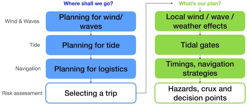
Looking at each step in a bit more detail (some of the terms and ideas below might not make sense until you’ve read the rest of these notes):
Planning for wind/waves
Do we need to hide from the wind / waves, or start downwind? What options does that permit?
Obtain forecasts - e.g. www.windy.com / www.windfinder.com / www.surfline.com / shipping forecast
Check wind strength and wave size. Is the wind light enough (e.g. F1) that we can ignore it? Is it strong enough (e.g. F4 or more) that we need to hide from it behind land? If not, it’s probably still sensible to plan a paddle that starts by paddling upwind, so that the wind is behind us at the end of the day.
Find wave height and period. Do we need to hide from the waves - where will the fetch be less? Are the waves suitable for rockhopping? For surfing What direction will the waves be coming from - will they make it hard to paddle?
Assuming we need to consider wind / waves, use an overview map of the area to identify coastlines that we might be able to paddle on and access points that allow us to start upwind. This should give us a short-list of options.
Planning for tide
Does the tide limit our options in this area? When is HW/LW, what is the general tidal flow picture (flow atlas)?
Obtain HW/LW times for a reference port - from almanac or (e.g.) easytide.admiralty.co.uk . Remember to correct for BST if applicable. Use the HW times to annotate a flow atlas with the times for the day.
Are there any tidal effects (height of tide, tidal streams) to worry about for the areas in our short list? Might we want:
Tidal flow behind us to make the paddle easier?
To avoid wind against tide effects?
To arrive at salient points at slack tide for more benign conditions?
Tide turning at our turnaround point?
Fast tides for playing?
High water for easier access or to navigate shallow channels? Or low water to explore drying reefs?
Planning for logistics
How far do we want to go? What access points are available?
There are typically many factors to consider - e.g: access/egress points, distance to carry the boats, transport, cafes, group aspirations, likely group paddling speed and endurance.
Selecting a trip
What options are sensible? Which one is best?
Are there any other limits to our options or hazards to consider - e.g. other water users, danger areas, logistics, lack of escape routes?
It’s obviously critical that the weather conditions are within the skills of the group to handle. If the conditions are not right for you or those you paddle with, then do not get on the water. To avoid disappointment, it is sensible to have a fallback plan in mind, especially if people have traveled a long way.
We should now have a list of options that are safe and practical. As a group, we can discuss which we’d prefer to do.
Local wind / wave / weather effects
How will the waves / waves interact with topography/tide? Other weather considerations?
Confirm wind and waves for the area. How will they change through the day? How do we expect the shape of the coastline to interact with wind and waves?
For wind consider:
How much shelter the coastline will offer - how high are the cliffs?
Will valleys funnel wind?
Do we expect a sea breeze / stronger winds in the afternoon
For waves consider:
Waves get steeper and may break in shallow water
Waves will refract into shallower water, concentrating power onto headlands
Waves will diffract around obstacles - entering areas that appear sheltered, with less height
Waves reflecting off cliffs form chapatis and confused seas
Surf depends on wave height / period and beach steepness
Other possible weather considerations include:
Will visibility be reduced? Can we navigate competently despite this?
Any possibility of thunderstorms?
Will temperature / wind / precipitation chill the group? Are they dressed appropriately?
Tidal gates
Where are the tidal gates and what times do they turn? Can we use the tide to our advantage?
Find reference port used in the guidebook / pilot, and look up tide times, correcting for BST if required.
Calculate local high and low water using high water constant.
Calculate slack water times using data from guidebook / pilot.
Draw a sketch map with the key information on, decide on trip timings.
Consider interactions of tidal streams with wind and/or waves
Hazards, crux and decision points
Identify hazards, crux points and decision points. How will we make the decisions, what are our fallback plans?
Do we need to consider any other factors (e.g. shipping, local rules…)?
What are the main hazards and where are the crux points of the trip (e.g. exposed sections, headlands, concentrated wind, waves or tidal stream?). Where are our key decision points to keep going or turn back? Where else can we get off if things go wrong? How will we make those decisions? Do we have fallback plans if conditions prove worse than expected? At what points do we become committed? What will we do if things go wrong at each point?
Check that the plan is sensible - if not, consider other venues.
Finish by copying key information to the map that you will carry on the water. Aim to keep your plans flexible - consider different options and be prepared to change if things don’t turn out as expected.
Checking actual conditions
It’s wise not to rely completely on the forecast. Take time when you arrive at your launch point to check that conditions you see out on the water are those that you expect. Is the wind direction about what you expect? Does the effect of the wind on the sea match what you’d expect from the Beaufort Scale descriptions? Keep an eye on the weather and the sky to see how the weather develops.
Copyright and permissions
One of the challenges in teaching tidal planning and navigation is giving students access to realistic materials without spending lots of money or infringing copyright. Resources used here include:
- Very small extracts from OS maps, originally sourced through the Bing service before it was discontinued. Because Bing maps use a different projection to the Ordnance Survey, these maps will appear tilted from their normal orientation. In using these small extracts from a single OS map I rely on exceptions in UK copyright law for review and teaching. OS maps contain OS data © Crown copyright and database rights.
- My home-made time tables - these are based on Environment Agency tide gauge data from the real-time data API (Beta) (public sector information licensed under the Open Government Licence v3.0) and created using Wesley Bowman’s Python implementation of UTide.
- Admiralty pilots that are sufficiently old that the Crown Copyright has expired.
- Admiralty charts (0034 Isles of Scilly & 1971 Cardigan Bay Northern Part), licensed from the UKHO (license number 36411). All charts are © Crown Copyright and/or database rights. They are NOT FOR NAVIGATION. Reproduced by permission of the Controller of Her Majesty’s Stationery Office and the UK Hydrographic Office (www.GOV.uk/UKHO).
- US government materials and publications (the US government does not enforce copyright on these)
- Small extracts from copyrighted materials (e.g. sea kayak guidebooks, app screenshots) for the purpose of review - I believe this constitutes ‘fair use’, and where such materials are used, I include a clear reference to the materials, normally with a strong endorsement of them!
- Some UK government materials, licensed under the Open Government License.
- Holmes, Ian. (2017). Mean High Water Springs Polygon, [Dataset]. University of Edinburgh. https://doi.org/10.7488/ds/1969, licensed under the Open Government License. These data are used as a basis for simple map diagrams.
- Images taken or made by myself or those I paddle with - thanks especially to Alison and Joe for the stunning images!
The material in this book is subject to copyright, and may not be used without permission. However, you are free to use it for teaching kayaking on a non-commercial basis. Please do contact me if you’d like to make use of it for other purposes (rbown (at) cantab (dot) net) - generally, I’m happy that my work can be useful to people!